Navigate the city
you live in
Real-time matatu tracking, AI-powered routing, and service alerts, built for how Nairobi actually moves.
134
Routes
2,400+
Stops
50K+
Daily riders
Everything you need to move
Built from the ground up for Nairobi's complex transit network, not a watered-down port of a Western app.
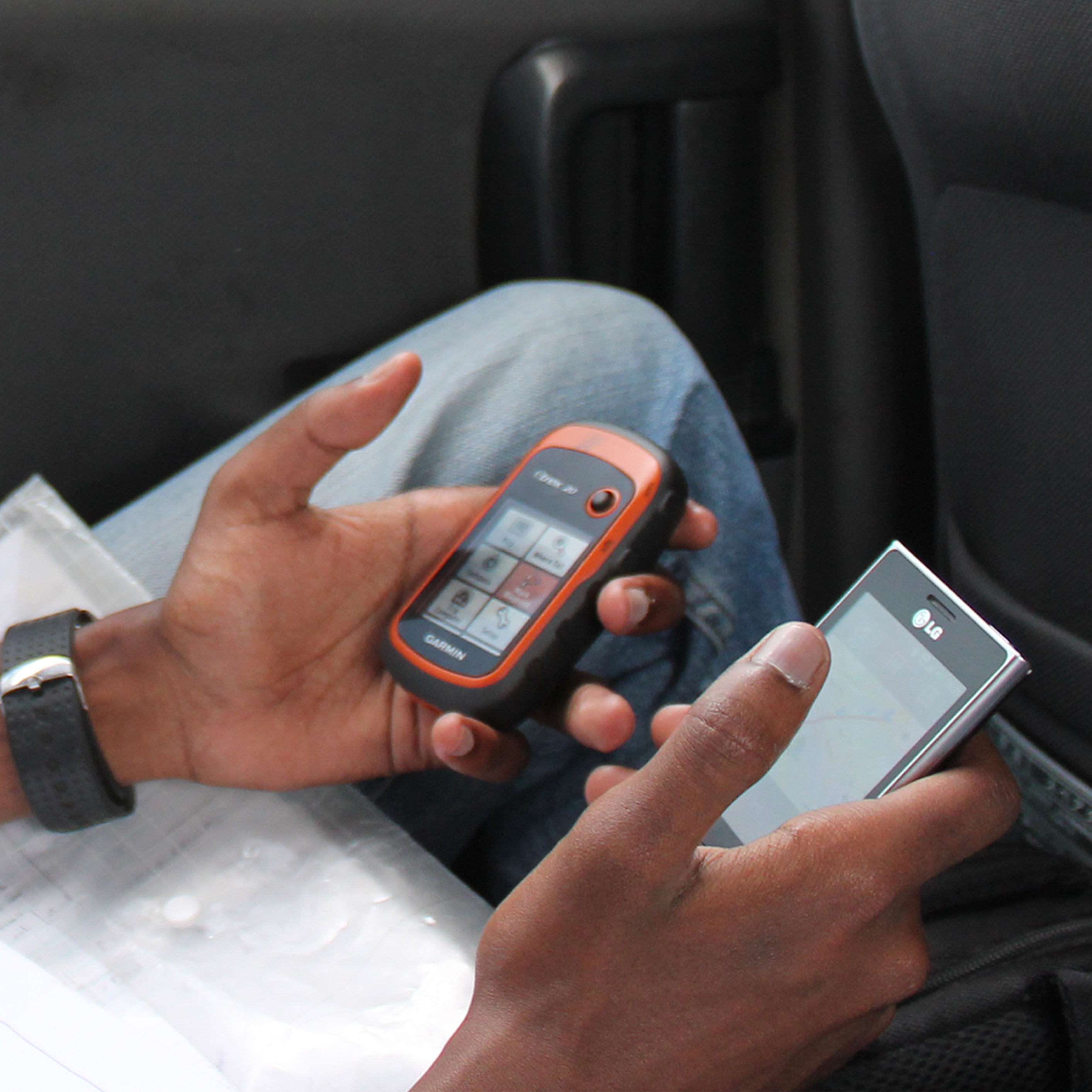
Ask Kwame
Talk or type where you're going in plain language. Kwame understands Nairobi context, your saved home, work, and school addresses, and launches turn-by-turn navigation the moment it has a route. Voice input with live waveform feedback, powered by Gemini.
Turn-by-Turn Navigation
Projection-based positioning maps your GPS onto the route polyline, not just proximity, so step advancement stays accurate through noisy urban GPS. Live ETAs, off-route alerts, and automatic rerouting.
Service Alerts
Real riders submit delay and diversion reports as they happen. Three verified reports in 15 minutes auto-triggers a live alert for everyone on that route.
Safiri Points
Earn points for every contribution, 3 for a delay report, 10 for a stop review, up to 50 for an approved new stop. Progress through 7 tiers from Commuter to Community Elder and compete on the city leaderboard.
Community Contributions
Six contribution types: delay reports, stop reviews, stop photos, info edits, route corrections, and new stop suggestions. Each goes through community voting before it goes live.
Stop Discovery
Search any stop or area and see real GTFS route data, community safety and comfort ratings, crowdsourced photos, and a one-tap shortcut to start navigating.
Saved Places
Pin home, work, and school for one-tap routing at any time. Organize everywhere else into Favorites, Travel Plans, and your own custom lists.
Three taps to destination
Open Hopln
Your location is detected automatically. No typing needed, just open and go.
Search destination
Type a stage or landmark. Hopln understands how Nairobians actually talk.
Go
Turn-by-turn guidance through every transfer, with live vehicle positions.
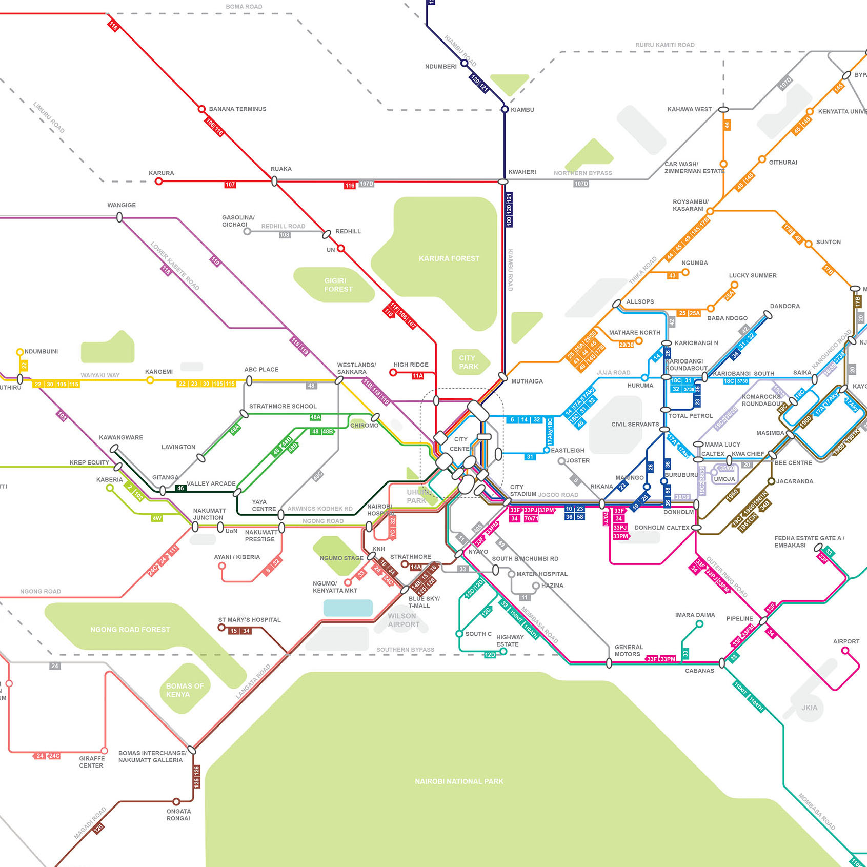
Your city,
mapped.
routes across Nairobi, tracked, verified, and updated in real time by local riders.
Stop Activity
Nairobi's transit
finally mapped.
Hopln's route network and stop data are built on the foundation laid by Digital Matatus , a research collaboration that produced the first open GTFS dataset of Nairobi's informal matatu system.
Before their work, Nairobi's transit data was inaccessible and unreliable. Student researchers from the University of Nairobi rode every route themselves, collecting GPS traces and building the first comprehensive map of the city's 14-million-trip-per-year informal network.
"Free, public data spurs innovation and improved services for citizens."
5,000+
Map downloads in 6 months
130+
Routes documented
2014
First published
GTFS
Open data standard
Research Partners


The city,
teaching itself.
Every rider who reports a delay, verifies a stop, or corrects a route makes the network smarter for the next person. Your knowledge is the map.
Real, lasting impact
Approved contributions go live immediately. Every rider on that route benefits from your report the moment it clears review.
Earn Safiri Points
+3 for a delay report, +10 for a stop review. Level up through 7 tiers, from Commuter to Community Elder.
Badges & Leaderboard
Unlock exclusive achievement badges tied to specific milestones and climb Nairobi's city-wide contributor ranking.
Run your SACCO like a modern operator.
Hopln Console gives transit operators enterprise-grade dispatch, ledger, and routing tools, without the enterprise price tag.

Live Fleet Map
Real-time vehicle positions with bearing arrows, refreshed every 5 seconds. On-time percentage, average delay, ghost trip detection, and full position history playback.
Ledger & Settlements
Multi-wallet system, vehicle, SACCO, and platform balances tracked separately. Automated revenue splits with per-vehicle and per-route reporting across 7, 30, and 90-day windows.
Service Alerts
Publish detours, reduced-service notices, and cancellations with info, warning, or critical severity. Alerts propagate instantly to riders in the Hopln app.
Route & Trip Editor
Map-based editor for routes, trips, and shapes with Mapbox integration. Full GTFS support, route colours, short names, trip variants, all editable without touching raw files.
On-Time Performance
Delay heatmaps by day and hour, journey counts, and top origin-destination pairs. Multi-period dashboards show exactly where your network under-performs.
Crew & Vehicle Management
Driver profiles, licence tracking, and vehicle assignments in one place. Set status (active, inactive, suspended) per vehicle and monitor the full fleet roster.
Network Planning
Coverage heatmaps, desire lines from real journey data, headway optimizer, and what-if scenario modelling, all without touching production data.
Your city
in your pocket.
Turn-by-turn matatu navigation, community-verified stops, and service alerts, built for the way Nairobi actually moves. Earn Safiri Points for every contribution that makes the city smarter.


From over 12,000+ daily commuters.